
Trails Overview
The designers of the system, both professional ecologists, have attempted to weave the trails into the landscape rather that to impose them on the landscape. All trails are relatively narrow and long, straight sections of trail have been minimized. With few exceptions, the downhill run-outs are straight for the sake of safety.
The trail system is laid out in the form of "nested" loops. This configuration has the advantage of optimizing the use of the available terrain while maximizing the total trail distance. The system was designed primarily with the recreational skier in mind while, at the same time, being sufficiently demanding to satisfy the serious or competitive skier. The emphasis, however, has been on aesthetics and safety.
The BioSki trails come under the umbrella of a larger body, the South Shore Rim trail system that includes Laurentian University and the Laurentian Nordic Ski Club. However BioSki is autonomous with respect to grooming and funding.
Cross-Country Ski Trails
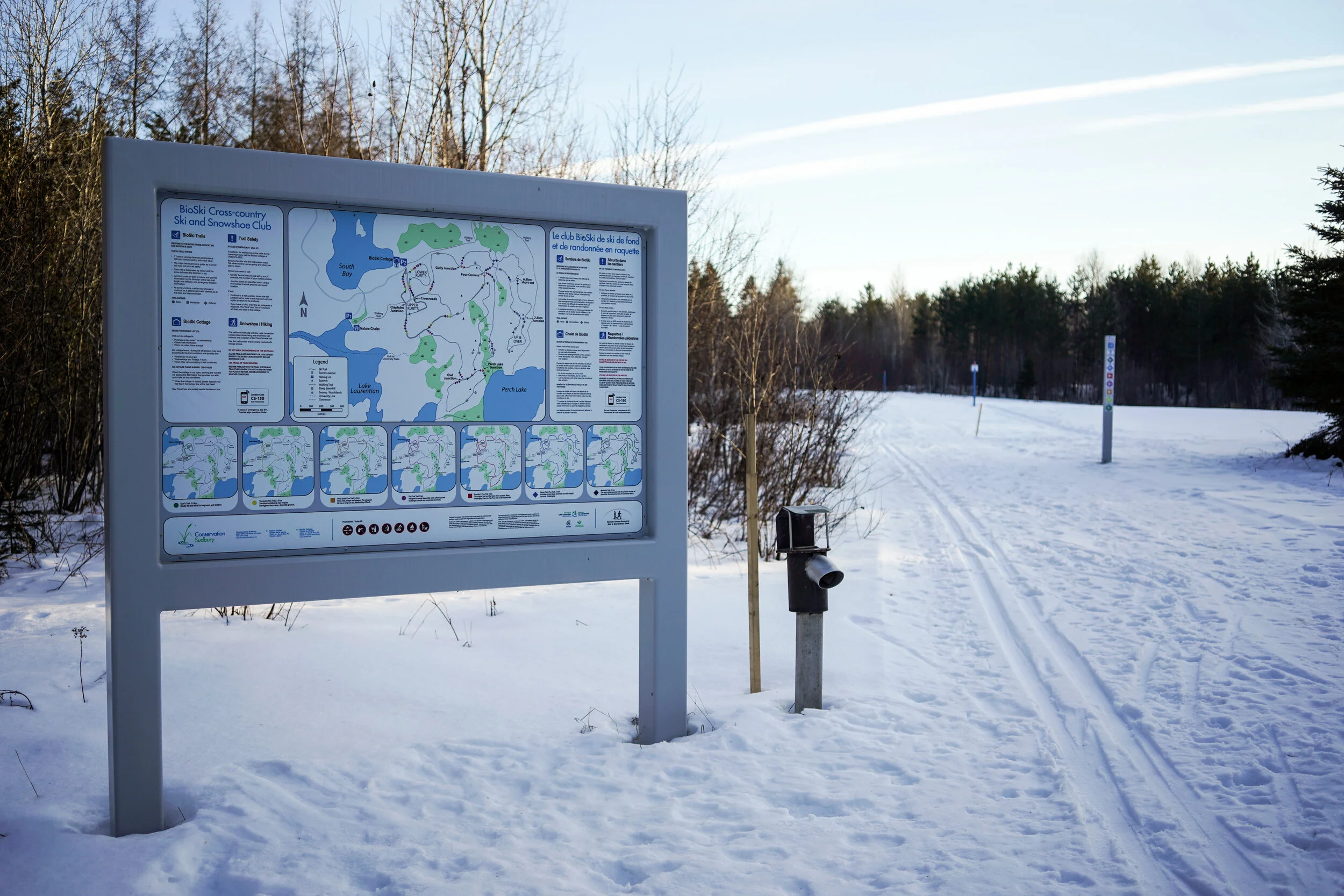
We offer single track, classic only ski trails with occasional double track sections. The system offers a whole range of options with trail lengths of: 1.8 km (green), 2.5 km (yellow), 3.5km (orange), 5 km (purple or red), 7.5 km (blue), and 10 km (black). The green trail is mostly flat and is popular with beginners and families with young children. The "Founders Five" (red trail), a 5 km trail, may be regarded as the heart of the system with other trails either cutting across it or connecting with it. The "Flat Five" (purple trail), also 5 km has been laid out in such a way as to by-pass steep hills. This trail is suited to those wishing to avoid the most challenging hills and to times when icy conditions make the hills hazardous.
Each junction is marked by a grey post that is designed to aid in navigating the trail system and carries information in the case of injury. Each post has an unique emergency locator number that should be used if you call 911. A map of the trail system also bears the location of the junction with a "You are here" symbol. In addition, all trails are signed by colour according to distance, degree of difficulty, and direction of travel.
NEW! The latest version of the GPS’d BioSki ski trail map has been updated and uploaded to Google maps. Assuming you have the Google Maps app downloaded on your smartphone, you can locate your position on the ski trail in real time by clicking here.

Snowshoe Trails
There are approximately 8 km of trails dedicated solely to snowshoeing with cut-offs for those who prefer a shorter distance. The trails may be accessed either from the ski cottage or from the Moonlight Beach Road. The two highest points on the trail afford scenic views; one to the north over Lake Ramsey and the other (known by snowshoers as "Mount Ramsey") overlooks the entire area.
Feb 25, 2021 NEW SNOWSHOE TRAIL! Take a tour of the latest snowshoe trail in the Bioski family, yet to be named.
Enter on the right just after the snowshoe trailhead and follow the blue arrows to immerse yourself in the beautiful pine, birch, spruce stands. This single track link from the snowshoe trailhead to the Perch Lake trail is approx 1.5 km. Once you arrive at the Perch Lake trail (orange), you can turn left to connect with the Beaver Pond trail(red) back to the parking lot or turn right to go to the end of the Perch Lake trail.
BioSki from above
Other Sudbury area Trails
Rainbow Routes
Rainbow Routes Association is a not-for-profit organization dedicated to sustainable mobility through the development and promotion of active transportation routes, including the Trans Canada Trail, in Greater Sudbury.
Laurentian Nordic
Laurentian Nordic Ski Club (LNSC) is a volunteer-run, community-based incorporated club offering fully groomed classic and freestyle cross-country ski trails.